- World Population Review Newsletter
- Posts
- Nations Quietly Rising, Tilting, or Sinking
Nations Quietly Rising, Tilting, or Sinking
How slow geological forces are quietly reshaping nations and coasts.
Philip Saparov
March 10, 2026
In partnership with
Greetings, inquisitive mind of world events!
Maps make the world look stable. Coastlines seem fixed, cities feel anchored, and borders appear permanent.
But the ground beneath them is quietly moving.
Across the planet, entire countries are slowly rising, sinking, or tilting—often just millimeters per year. Hardly noticeable in a lifetime, yet powerful enough over decades to reshape coastlines, flood cities, and alter the geography of nations.
Here are seven places where the Earth itself is quietly rewriting the map.
Find out why 200K+ engineers read The Code twice a week

Staying behind on tech trends can be a career killer.
But let’s face it, no one has hours to spare every week trying to stay updated.
That’s why over 200,000 engineers at companies like Google, Meta, and Apple read The Code twice a week.
Here’s why it works:
No fluff, just signal – Learn the most important tech news delivered in just two short emails.
Supercharge your skills – Get access to top research papers and resources that give you an edge in the industry.
See the future first – Discover what’s next before it hits the mainstream, so you can lead, not follow.
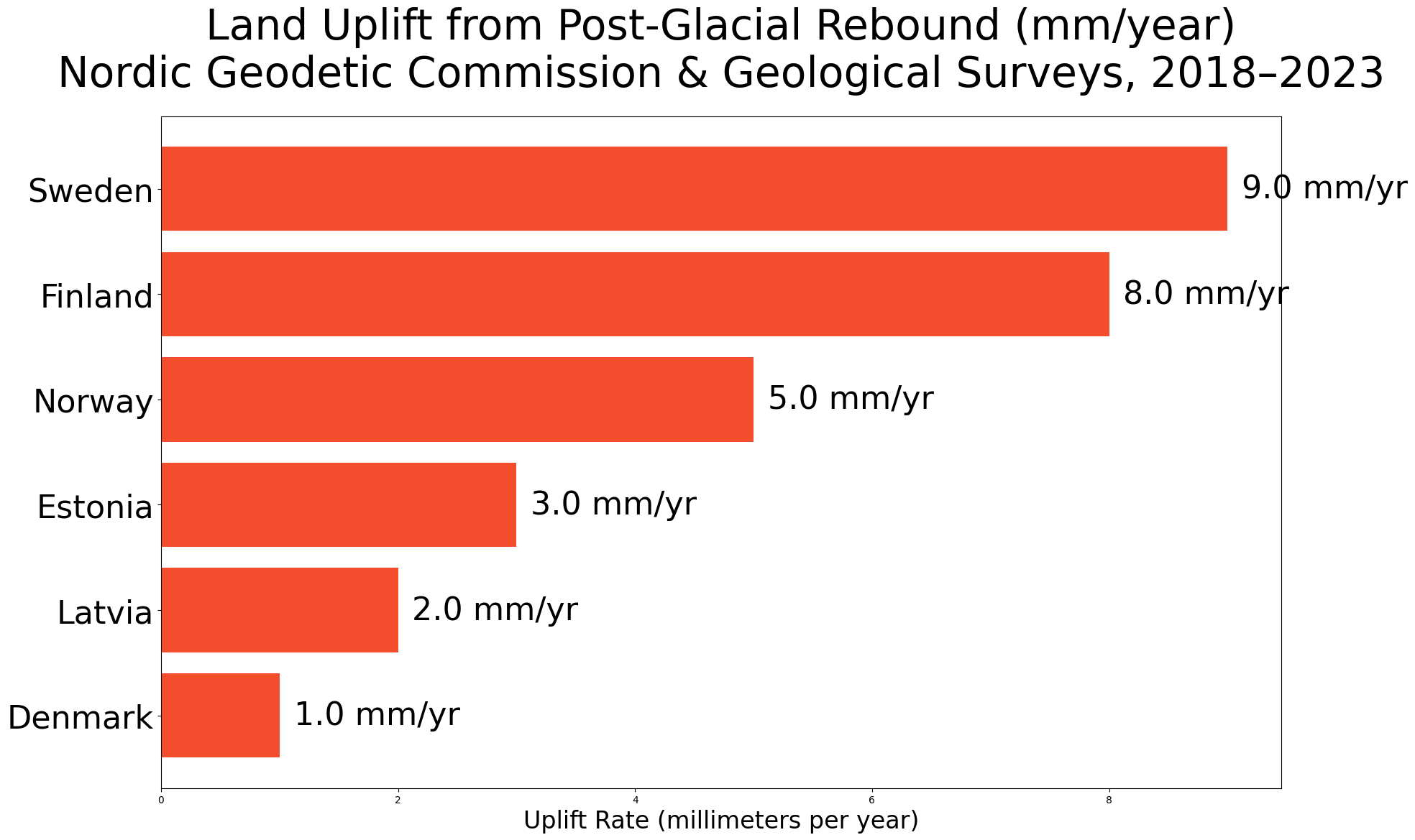
Not all land is sinking—some is still rising from ancient ice.
After the last Ice Age ended roughly 10,000 years ago, massive glaciers melted away from northern Europe. The weight they once placed on the crust had pushed the land downward. With that weight gone, the region has been slowly rebounding upward ever since in a process known as post-glacial rebound.
Three countries sit at the center of this geological lift:
🇸🇪 Sweden is rising fastest, with parts of the Gulf of Bothnia climbing nearly 9 millimeters per year.
🇫🇮 Finland is experiencing similar uplift, gradually exposing new islands and shorelines along its western coast.
🇳🇴 Norway is rising more unevenly, with the strongest uplift inland where the glaciers were thickest.
Putting it into perspective: In parts of northern Sweden, the coastline has moved over 300 meters outward since the Viking Age, quietly expanding the landmass generation after generation.
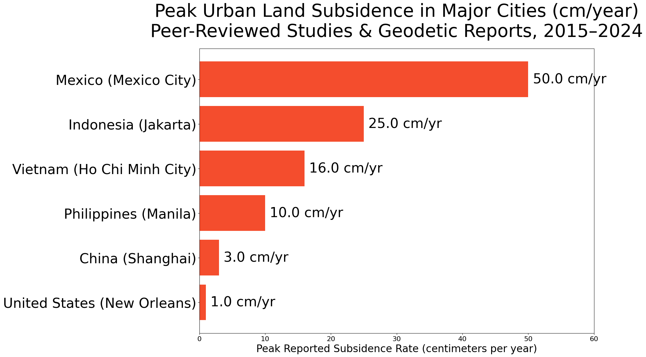
While some lands rise naturally, many modern cities are sinking—often because of human activity.
Urban subsidence occurs when groundwater is pumped from beneath cities or when heavy infrastructure compresses soft sediment. Over time, the ground slowly settles.
Three major cities illustrate the trend:
🇮🇩 Jakarta is sinking faster than almost any city on Earth, in some places by 25 centimeters per year, largely due to groundwater extraction.
🇲🇽 Mexico City, built on an ancient lakebed, has already dropped over 10 meters since the early 1900s.
🇨🇳 Shanghai has reduced its sinking through strict water regulations, but parts of the city still subside several millimeters annually.
Putting it into perspective: In Mexico City, historic buildings that once stood level now visibly lean because the city’s soft clay soil compresses unevenly under urban weight.
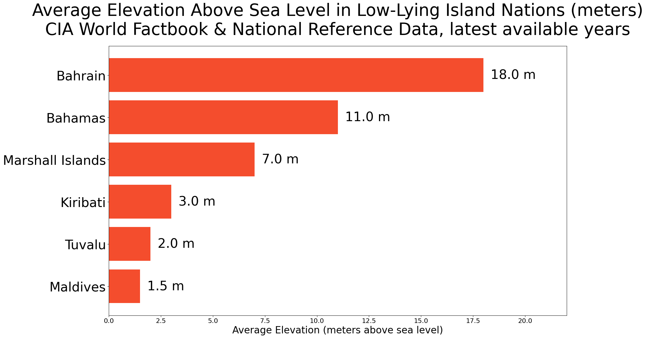
For many small island states, geological motion and rising seas combine into a serious long-term challenge.
Low-lying coral islands sit only a few meters above sea level. Even slight subsidence—or sea-level rise—can dramatically increase flooding risk.
Three nations are closely monitored by scientists:
🇲🇻 Maldives has an average elevation of just 1.5 meters above sea level, making it one of the world’s lowest countries.
🇰🇮 Kiribati, spread across the central Pacific, faces saltwater intrusion affecting freshwater supplies.
🇹🇻 Tuvalu has explored contingency plans for relocating citizens if long-term flooding worsens.
Putting it into perspective: Kiribati has already purchased 20 square kilometers of land in Fiji as a potential future relocation option—one of the first examples of climate-driven sovereign contingency planning.
If You Could Be Earlier Than 85% of the Market?

Most read the move after it runs. The top 250K start before the bell.
Elite Trade Club turns noise into a five-minute plan—what’s moving, why it matters, and the stocks to watch now. Miss it and you chase.
Catch it and you decide.
By joining, you’ll receive Elite Trade Club emails and select partner insights. See Privacy Policy.
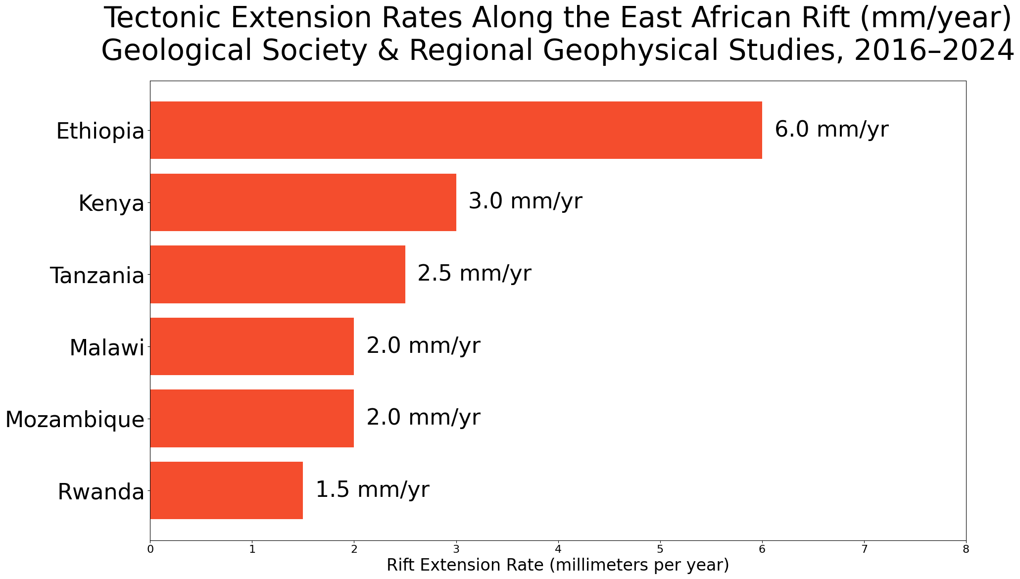
In East Africa, the Earth’s crust is slowly pulling apart.
The East African Rift System is a vast geological fracture stretching from Ethiopia to Mozambique. Here, tectonic forces are gradually splitting the African Plate into two pieces.
Three countries sit along this evolving divide:
🇪🇹 Ethiopia, where dramatic volcanic landscapes and deep valleys mark the northern rift.
🇰🇪 Kenya, home to the famous Rift Valley lakes formed by tectonic stretching.
🇹🇿 Tanzania, where the rift continues south toward Mozambique.
Putting it into perspective: Geological models suggest that in 10–20 million years, the eastern portion of Africa could separate entirely, forming a new ocean basin.
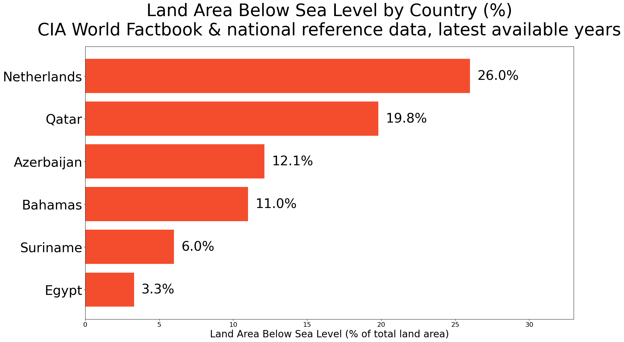
Few countries manage sinking land as actively as the Netherlands.
Much of the country sits below sea level, and centuries of drainage have caused peat soils to compress and sink. Combined with rising seas, the challenge is constant.
Three key strategies define the Dutch response:
🇳🇱 Delta Works, one of the largest flood defense systems ever built.
🇳🇱 Room for the River, a project that gives rivers more space rather than simply raising barriers.
🇳🇱 Floating infrastructure, including experimental neighborhoods designed to rise with water levels.
Putting it into perspective: Without its vast system of dikes and pumps, roughly one-third of the Netherlands would be underwater today.
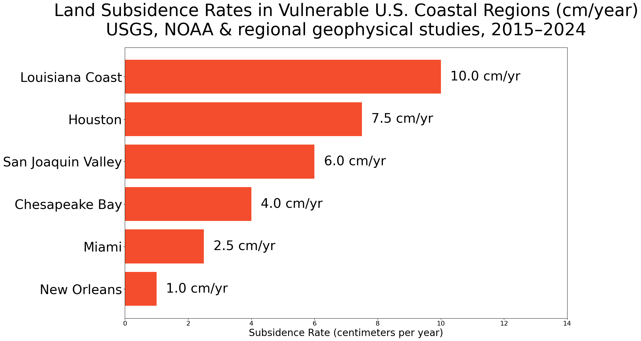
The United States also faces subtle geological shifts, particularly along its coasts.
While sea-level rise receives attention, land subsidence can amplify its impact dramatically.
Three vulnerable regions stand out:
🇺🇸 Louisiana’s Gulf Coast, where wetlands are disappearing as sediment compacts and river flows change.
🇺🇸 Virginia’s Chesapeake Bay region, where both sea rise and land sinking increase flooding risk.
🇺🇸 California’s Central Valley, where decades of groundwater pumping have caused some areas to sink more than 8 meters since the 1920s.
Putting it into perspective: Louisiana has lost over 2,000 square miles of coastal land since the 1930s—an area roughly the size of Delaware.
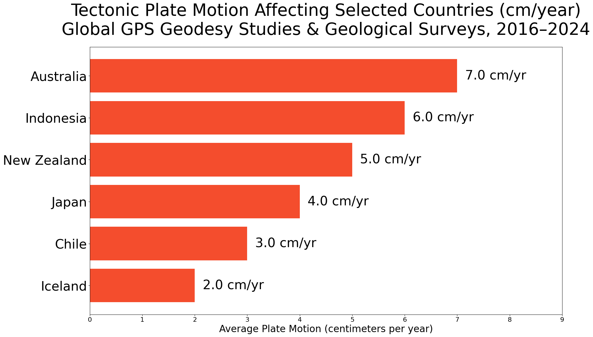
Beyond local sinking or rising, entire countries are drifting across the planet due to plate tectonics.
These movements are slow but relentless.
Three striking examples:
🇮🇸 Iceland, where the North American and Eurasian plates are pulling apart, widening the island slightly every year.
🇯🇵 Japan, located at the junction of four tectonic plates, experiences both uplift and subsidence across different regions.
🇳🇿 New Zealand, straddling the Pacific and Australian plates, moves several centimeters each year along major fault lines.
Putting it into perspective: GPS measurements show that parts of New Zealand shift up to 5 centimeters annually, roughly the rate that human fingernails grow.
Maps may look permanent, but the ground beneath them is always moving. Slowly, quietly, the Earth is lifting some places while sinking others.
Over time, those millimeters matter. Coastlines shift, cities adapt, and entire regions rethink how—and where—they build.
For anyone considering where to live, invest, or retire, understanding these slow geological forces offers a clearer view of the world not just as it is today—but as it may become.
Warm regards,
Shane Fulmer
Founder, WorldPopulationReview.com
P.S. Want to sponsor this newsletter? Reach 140,000+ global-minded readers — click here!