- World Population Review Newsletter
- Posts
- When Borders Get Weird: Maps You Can’t Unsee
When Borders Get Weird: Maps You Can’t Unsee
Rivers, enclaves, and fractured nations that defy all logic and law.
Philip Saparov
November 28, 2025
In partnership with
Greetings, curious cartographer!
The map lies. Or at least, it hides things—rivers that betray their borders, towns trapped in the wrong country, nations split by invisible seams.
This week, we uncover the strangest borders on Earth—and the strange truths they reveal about power, history, and the human urge to draw lines. What you see isn’t always what you get.
Let’s dive into the map’s weirdest secrets.
$1K Could’ve Made $2.5M

In 1999, $1K in Nvidia’s IPO would be worth $2.5M today. Now another early-stage AI tech startup is breaking through—and it’s still early.
RAD Intel’s award-winning AI platform helps Fortune 1000 brands predict ad performance before they spend.
The company’s valuation has surged 4900% in four years* with over $50M raised.
Already trusted by a who’s-who roster of Fortune 1000 brands and leading global agencies. Recurring seven-figure partnerships in place and their Nasdaq ticker is reserved: $RADI.
This is a paid advertisement for RAD Intel made pursuant to Regulation A+ offering and involves risk, including the possible loss of principal. The valuation is set by the Company and there is currently no public market for the Company's Common Stock. Nasdaq ticker “RADI” has been reserved by RAD Intel and any potential listing is subject to future regulatory approval and market conditions. Investor references reflect factual individual or institutional participation and do not imply endorsement or sponsorship by the referenced companies. Please read the offering circular and related risks at invest.radintel.ai.
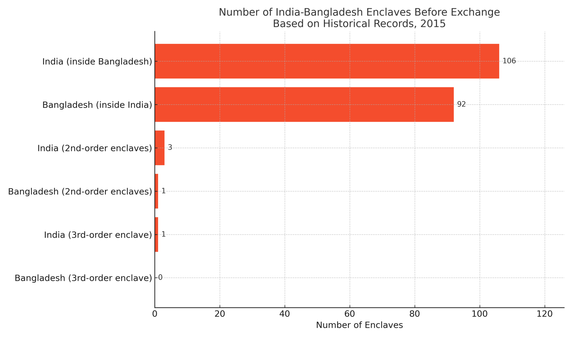
Imagine living in a country that’s inside another country, which is inside your country again. That was the real-life situation in Cooch Behar, where over 160 Indian and Bangladeshi enclaves once existed—some nested three layers deep.
For decades, residents lived in limbo: technically citizens, but without services like electricity or law enforcement. Many had no passports, and basic needs required crossing hostile borders. In 2015, after years of negotiation, India and Bangladesh finally exchanged enclaves, untangling this geographic mess.
Today, the area is an unlikely case study in how borders can trap people—literally.
📌 Strange fact: One Indian enclave was entirely inside a Bangladeshi enclave, itself inside another Indian enclave—a geographic Russian doll.
Before 2015, India and Bangladesh shared over 200 enclaves, some nested multiple layers deep. This chart breaks down the number and complexity of these enclaves by country.
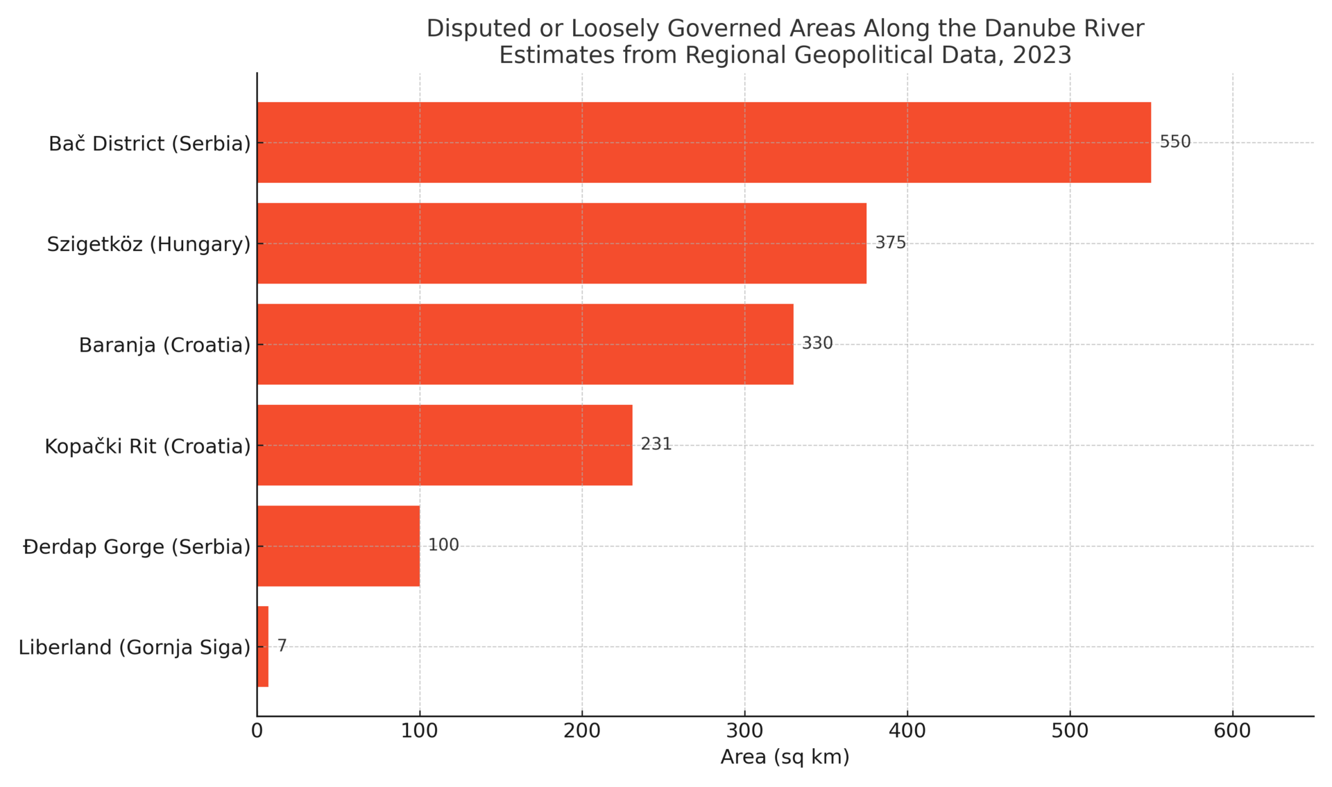
When the Danube River shifted course, it didn’t just change the land—it opened a legal loophole. Between Croatia and Serbia lies a tiny patch of unclaimed land called Gornja Siga. In 2015, Czech libertarian Vít Jedlička declared it the Free Republic of Liberland, arguing that neither Croatia nor Serbia claimed the land.
Despite global indifference and border guards who regularly block access, Liberland has its own flag, constitution, and thousands of online “citizens.”
Could a shifting river really create a new nation? Maybe. At the very least, it shows how a natural border can spawn legal gray zones—and political fantasy.
📌 Strange fact: Liberland claims to be the third-smallest sovereign entity in the world—after the Vatican and Monaco.
This graph depicts six loosely governed or disputed areas along the Danube River, highlighting how Liberland, though tiny, symbolizes a broader pattern of border ambiguity across the region.
In the quiet town of Baarle, the border isn’t a line—it’s a tangle of enclaves. The town features 22 Belgian enclaves inside the Netherlands, and 7 Dutch counter-enclaves inside them.
Here, a shop’s front door may be in one country, the cash register in another. At Café Den Engel, tables cross international lines—changing tax laws and even curfews with each step.
Rather than resist it, Baarle has embraced the absurdity, turning its checkerboard of sovereignty into a civic marvel and tourist attraction.
📌 Strange fact: To avoid legal confusion, local rules dictate that a house’s country is determined by where the front door lies. Some homeowners have moved their doors to change their legal address.
This graph depicts the number of enclaves in the Baarle region compared to global enclave trends, illustrating just how unique and intricate the Belgium–Netherlands border really is.

Wall Street Isn’t Warning You, But This Chart Might
Vanguard just projected public markets may return only 5% annually over the next decade. In a 2024 report, Goldman Sachs forecasted the S&P 500 may return just 3% annually for the same time frame—stats that put current valuations in the 7th percentile of history.
Translation? The gains we’ve seen over the past few years might not continue for quite a while.
Meanwhile, another asset class—almost entirely uncorrelated to the S&P 500 historically—has overall outpaced it for decades (1995-2024), according to Masterworks data.
Masterworks lets everyday investors invest in shares of multimillion-dollar artworks by legends like Banksy, Basquiat, and Picasso.
And they’re not just buying. They’re exiting—with net annualized returns like 17.6%, 17.8%, and 21.5% among their 23 sales.*
Wall Street won’t talk about this. But the wealthy already are. Shares in new offerings can sell quickly but…
*Past performance is not indicative of future returns. Important Reg A disclosures: masterworks.com/cd.
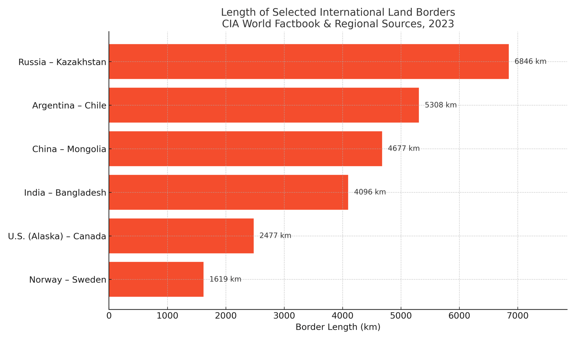
Most Americans forget that Alaska isn’t connected to the Lower 48—it’s separated by Canada. To drive from Seattle to Anchorage, you pass through British Columbia and Yukon, crossing two international borders.
This split geography has strategic, economic, and logistical implications. Everything from supply chains to internet infrastructure must accommodate international transit. Alaska’s energy exports, Arctic defense systems, and disaster responses are all shaped by this physical separation.
📌 Little-known fact: Alaska is so far west that the Aleutian Islands cross the 180th meridian, making Alaska both the westernmost and easternmost U.S. state.
This graph depicts the length of Alaska’s border with Canada relative to other prominent land borders, revealing that despite Alaska’s remoteness, its international boundary ranks among the longest in the world.
In the Bering Strait, two small islands—Big Diomede (Russia) and Little Diomede (USA)—sit just 2.4 miles apart, separated by the International Date Line. That means they’re 21 hours apart in time.
During the Cold War, the water between them was dubbed the "Ice Curtain." Big Diomede remains a Russian military zone. Little Diomede, home to an Alaskan Native village, survives in isolation, accessible only by helicopter or boat during the brief summer.
📌 Time warp fact: On a clear day, you can stand on Little Diomede and see tomorrow—literally—on Big Diomede.
This graph depicts some of the shortest distances between nations across land or sea, illustrating how the Diomede Islands represent both extreme geographic closeness and profound temporal separation.

Kaliningrad is a Russian exclave trapped between Poland and Lithuania, more than 300 miles from the rest of Russia. It was seized after WWII and remains a strategic naval base with one foot in Europe and another in Moscow’s orbit.
The region is heavily militarized and geopolitically sensitive. EU citizens must cross through Russia to reach it, and vice versa. And while the region uses the ruble, shops frequently list prices in euros to cater to visiting Europeans.
📌 Odd truth: Kaliningrad is closer to Berlin than to Moscow—and is not connected to mainland Russia by land.
This graph depicts six of the largest exclaves on Earth, showing how Kaliningrad dwarfs other separated territories—underscoring its geopolitical importance on Europe’s doorstep.

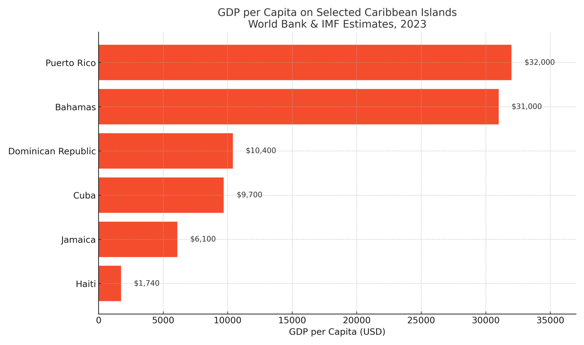
On the island of Hispaniola, two nations share space—but not circumstance. The Dominican Republic enjoys a stable tourism industry, growing economy, and preserved forests. Haiti, by contrast, faces persistent political instability and environmental degradation.
The differences are stark—even visible from above. Satellite images show the Dominican side lush and green, while Haiti appears deforested and dry.
This isn’t just a boundary—it’s a real-world example of how history, governance, and policy shape national destiny on shared terrain.
📌 Striking image: The Haiti–DR border is one of the few international borders clearly visible from space.
This graph depicts GDP per capita across six Caribbean nations, illustrating how Haiti’s economic struggles stand in stark contrast to both its island neighbor and the wider region.
Borders shape nations—but the strangest ones rewrite the rules. From citizenship to commerce, these twisted lines impact lives in ways most maps can’t explain. They’re not just boundaries—they’re stories, scars, and strategies etched across the earth.
Whether you’re eyeing a new place to live, invest, or simply understand, these oddities remind us: geography isn’t fixed. It’s human. And it’s always changing.
Stay sharp. Stay curious. The edges are where things get interesting.
Warm regards,
Shane Fulmer
Founder, WorldPopulationReview.com
P.S. Want to sponsor this newsletter? Reach 139,000+ global-minded readers — click here!